RPUB - Loakan (Baguio) Airport
General
Loakan Airport (RPUB), also known as Baguio Airport, is a Class 2 principal airport located in Loakan, Baguio City, Benguet. It has a single runway (09/27) and serves domestic passenger flights and general aviation.
- Main Terminal - Domestic Flights
The airport caters to passenger flights and general aviation.
High-elevation mountain airport
Baguio sits at 4251 FT in mountainous terrain, with a short 1566 M runway. Expect reduced aircraft performance (density altitude), terrain on all approaches, and often marginal mountain weather. Plan carefully.
Airspace
- Baguio ATZ — 5 NM arc centered on the ARP, surface up to but excluding 2000 FT AGL (Class B). Aerodrome control is provided by Baguio Tower (RPUB_TWR).
- There is no control zone, terminal area, or approach-control service at Baguio; it is a tower-only aerodrome.
- Transition altitude: not published.
Charts
Frequency List
| Designator | Callsign | Frequency | Remarks |
|---|---|---|---|
| RPUB_TWR | Baguio Tower | 123.500 | ATZ SFC - 2000 ft AGL |
| Unicom | — | 121.900 | When Baguio Tower is offline |
Runways
Baguio currently has 1 runway (09/27), 1566 x 36 M, concrete.
Runway 27 is served by a PAPI; runway 09 has no visual glide-slope guidance. There are no approach lights. The runway slopes uphill towards the threshold of runway 27 (THR 09 elevation 4198 FT, THR 27 elevation 4247 FT).
Below is a table of the declared distances.
Declared Distances (metres).
| Runway | TORA (m) | TODA (m) | ASDA (m) | LDA (m) |
|---|---|---|---|---|
| 09 | 1566 | 1626 | 1566 | 1566 |
| 27 | 1566 | 1686 | 1566 | 1566 |
Clearance
Baguio Tower provides aerodrome control only, and the aerodrome operates VFR. On first contact, give your parking position and aircraft type, and request your departure clearance.
Warning
Radio Checks on first contact are discouraged. Be concise on a controlled frequency, and read back your clearance in full.
Phraseology
RP-C123: Baguio Tower, RP-C123, GA apron, request VFR departure to the west.
RPUB_TWR: RP-C123, cleared VFR departure to the west not above [altitude], runway 27, squawk 12xx.
RP-C123: Cleared VFR departure to the west not above [altitude], runway 27, squawk 12xx, RP-C123.
Taxi
The apron connects to runway 09/27. Follow any instruction from Baguio Tower and the apron guide lines. With a single short runway, expect to backtrack to the threshold in use.
Warning
Never enter or backtrack the runway until you have been explicitly cleared to do so. Read back any hold short instruction with "HOLDING SHORT".
Phraseology
CEB123: Baguio Tower, CEB123, request taxi, runway 27.
RPUB_TWR: CEB123, taxi to holding point runway 27.
CEB123: Taxi to holding point runway 27, CEB123.
Departure
Baguio has no approach-control service, so Standard Instrument Departures (SIDs) or departure instructions are given by Baguio Tower. After departure, remain clear of terrain and climb on your cleared routing. After leaving the Tower's frequency it is highly suggested to monitor Manila Control (CTR) when one is online for traffic information.
Phraseology
CEB123: Baguio Tower, CEB123, ready for departure runway 27.
RPUB_TWR: CEB123, runway 27, cleared for take-off, wind calm.
Arrival
There is no radar approach service at Baguio. Establish contact with Baguio Tower on 123.5 MHZ approaching 15 NM inbound, and establish two-way radio contact by 5 NM. Expect a visual approach.
Phraseology
CEB122: Baguio Tower, CEB122, 15 miles east, inbound landing.
RPUB_TWR: CEB122, report 5 miles, runway 27, QNH 1012.
CEB122: Report 5 miles, runway 27, QNH 1012, CEB122.
VFR Area Chart
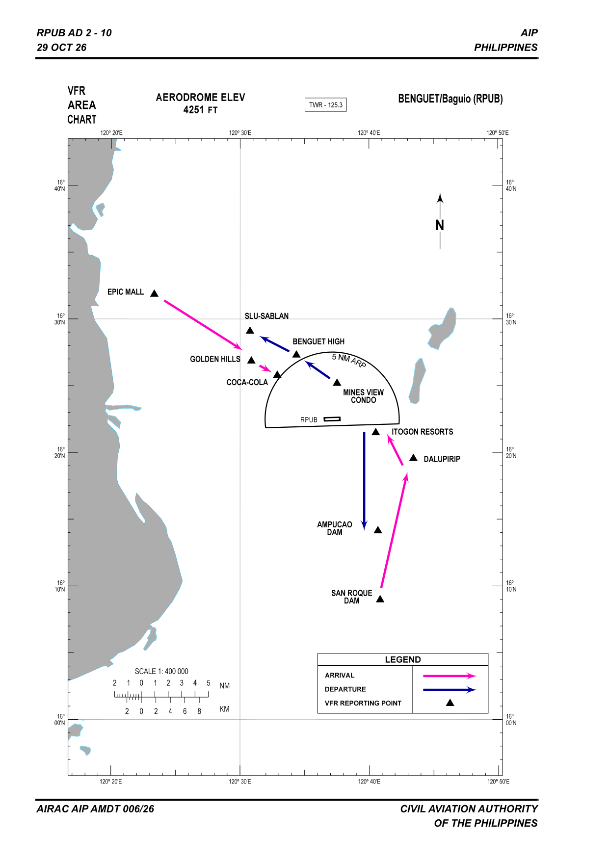
The chart shows the published VFR arrival (magenta) and departure (blue) routes and the visual reporting points around Baguio.
Traffic Circuit
High-altitude aerodrome and terrain
Baguio (Loakan) sits at 4,251 FT elevation, ringed by terrain above 5,000 FT. True airspeeds and groundspeeds are high for a given indicated speed — fly the circuit accurately and remain within the published pattern.
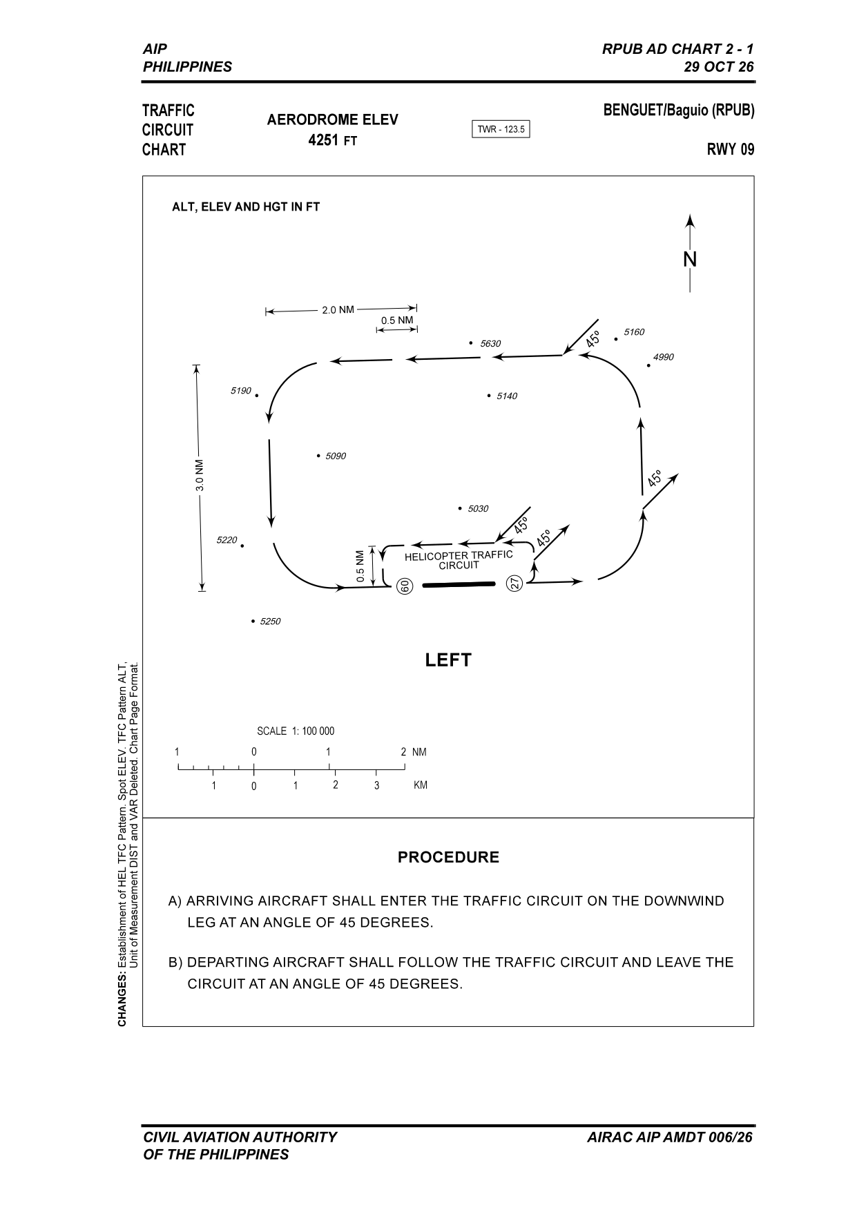
Left-hand circuit. Aircraft at 105 KT or less fly the inner circuit (0.5 NM from the runway); aircraft at 106 KT or more fly the outer circuit (2.0 NM). A separate helicopter traffic circuit is published.
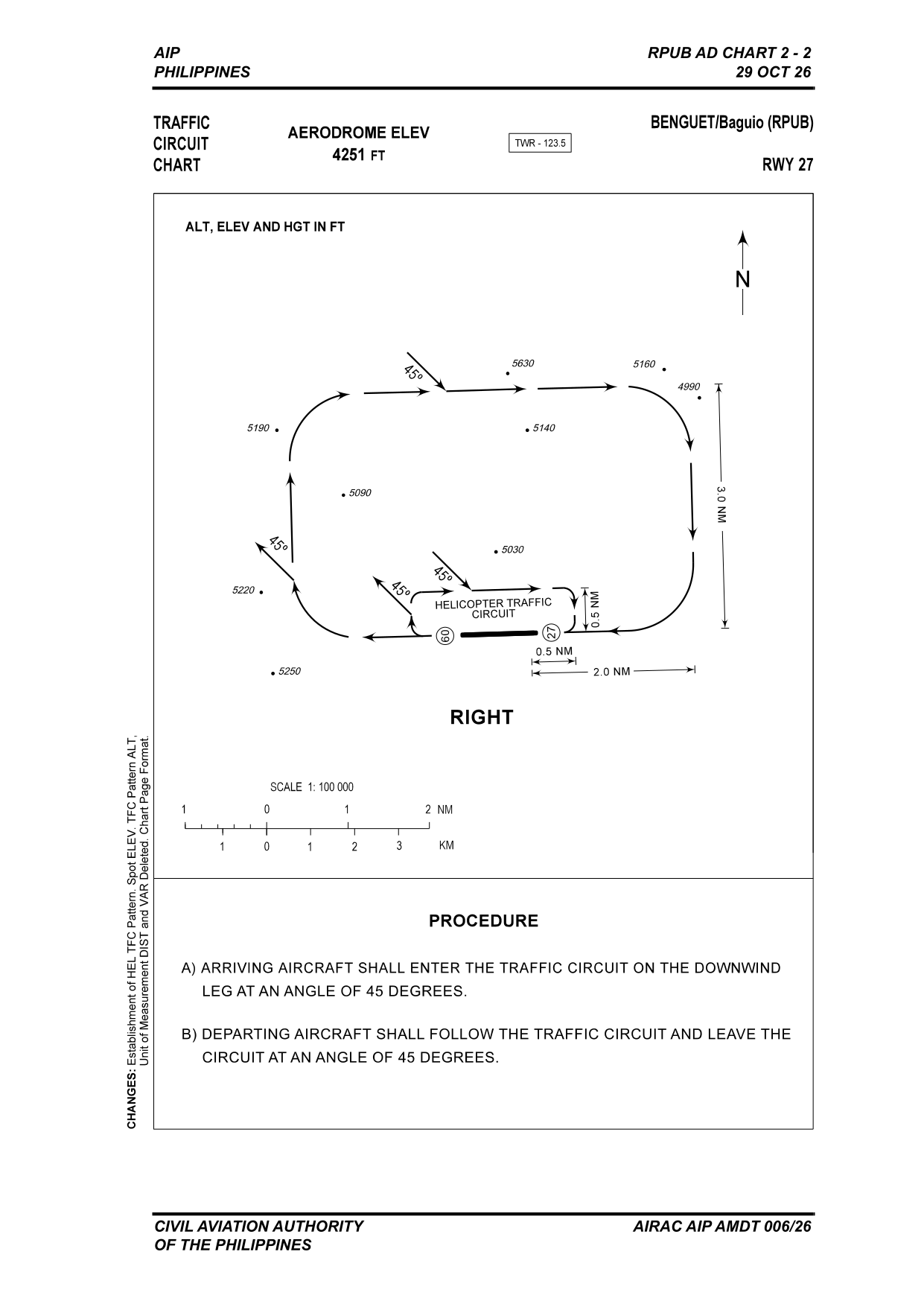
Right-hand circuit. Aircraft at 105 KT or less fly the inner circuit (0.5 NM from the runway); aircraft at 106 KT or more fly the outer circuit (2.0 NM). A separate helicopter traffic circuit is published.
Circuit entry and exit
- Arriving aircraft shall enter the traffic circuit on the downwind leg at an angle of 45 degrees.
- Departing aircraft shall follow the traffic circuit and leave the circuit at an angle of 45 degrees.