Visual Flight Rules (VFR) Within Butuan ATZ
VFR Area Chart
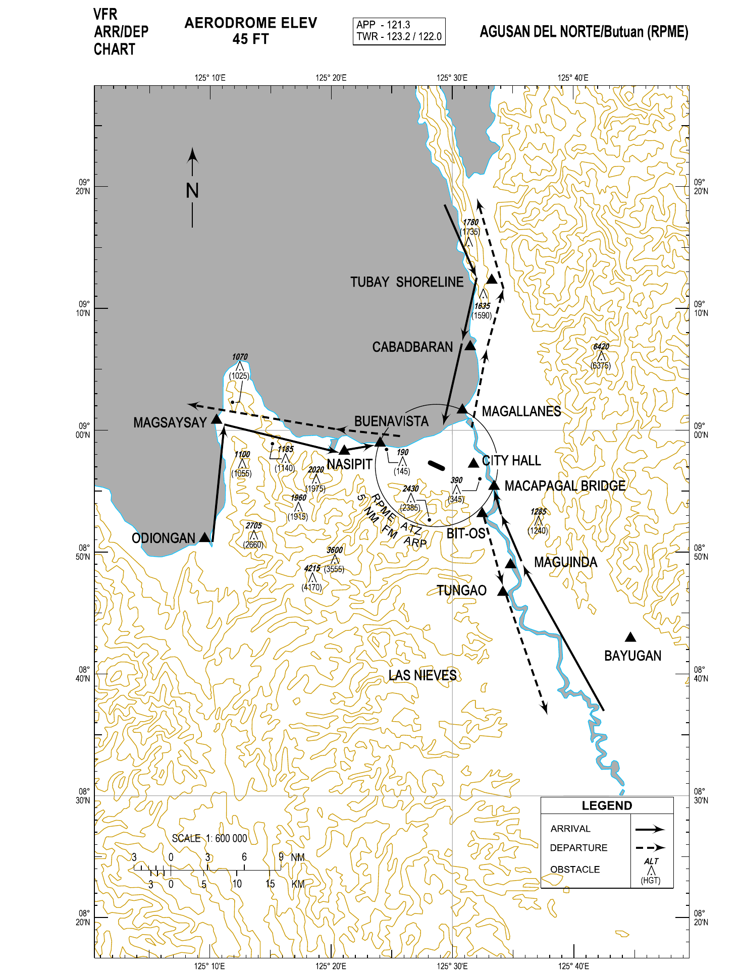
General Procedures for VFR Flights
The following air traffic procedures shall apply to all VFR flights when entering, leaving or operating within Butuan ATZ.
- All arriving VFR flights shall contact Butuan Approach on 121.3 MHZ upon entering Butuan TMA.
- All instructions and traffic information shall be acknowledged by pilots.
- IFR flights shall have priority over VFR flights.
- Any deviation from the procedures shall be advised without delay to Butuan ATC.
VFR Departures
North Bound: After airborne, turn left towards MAGALLANES shoreline. Report abeam CABADBARAN. Continue towards TUBAY SHORELINE. Report switching frequency or proceed as instructed by ATC.
South Bound: After airborne, fly towards Agusan River. Turn right abeam MACAPAGAL BRIDGE. Keep to the West of Agusan River. Report over BIT-OS. Report over TUNGAO. Report switching frequency or proceed as instructed by ATC.
West Bound: After airborne, make a left downwind departure towards BUENAVISTA shoreline. Request ATC clearance to cross final approach RWY 12. Continue westward and report abeam NASIPIT. Report abeam MAGSAYSAY. Report switching frequency or proceed as instructed by ATC.
If proceeding to Laguindingan Airport: from MAGSAYSAY, continue climb VFR on a west-north-west direction towards Camiguin Island. Report switching frequency to Laguindingan Approach or proceed as instructed by ATC.
North Bound: After airborne, turn right towards MAGALLANES shoreline. Continue to the North and report abeam CABADBARAN. Report TUBAY SHORELINE. Report switching frequency or proceed as instructed by ATC.
South Bound: After airborne, make a right downwind departure towards Butuan CITY HALL. Request ATC clearance to cross final approach RWY 30 towards West of MACAPAGAL BRIDGE. Keep to the West of Agusan River and report over BIT-OS. Report over TUNGAO. Report switching frequency or proceed as instructed by ATC.
West Bound: After airborne, turn left towards BUENAVISTA shoreline. Continue westward and report abeam NASIPIT. Report abeam MAGSAYSAY. Report switching frequency or proceed as instructed by ATC.
If proceeding to Laguindingan Airport: from MAGSAYSAY, continue on a west-north-west direction towards South of Camiguin Island then turn left on a south-south-west direction towards Laguindingan Airport. Report switching to Laguindingan Approach or proceed as instructed by ATC.
VFR Arrivals
From the North: Report abeam TUBAY SHORELINE. Follow Butuan Bay coastline and report abeam CABADBARAN. Report MAGALLANES shoreline. Request ATC clearance to join left downwind RWY 12 or proceed as instructed by ATC.
From the South: Report abeam BAYUGAN. Keep to the East side of Agusan River and report over MAGUINDA. Report abeam BIT-OS and request ATC clearance to cross final approach RWY 30 towards East of MACAPAGAL BRIDGE and to join left downwind RWY 12 or proceed as instructed by ATC.
From the West: Report abeam ODIONGAN. Follow Gingoog coastline and report abeam MAGSAYSAY. Turn right towards Butuan Airport and report over NASIPIT. Report approaching BUENAVISTA and request ATC clearance for a straight-in approach RWY 12 or proceed as instructed by ATC.
From the North: Report abeam TUBAY SHORELINE. Follow Butuan Bay coastline and report abeam CABADBARAN. Report MAGALLANES shoreline. Request ATC clearance to join right base RWY 30 or proceed as instructed by ATC.
From the South: Report abeam BAYUGAN. Keep to the East side of Agusan River and report over MAGUINDA. Report approaching MACAPAGAL BRIDGE and request ATC clearance for a straight-in approach RWY 30 or proceed as instructed by ATC.
From the West: Report abeam ODIONGAN. Follow Gingoog coastline and report abeam MAGSAYSAY. Turn right towards Butuan Airport and report over NASIPIT. Continue towards BUENAVISTA. Request ATC clearance to cross final approach RWY 30 and join right downwind RWY 30 or proceed as instructed by ATC.
Traffic Circuit
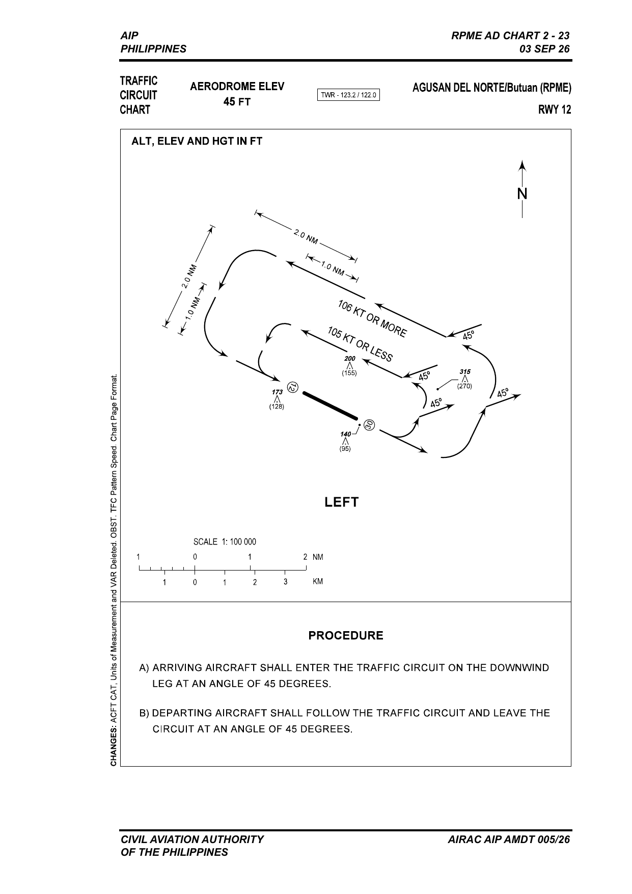
Left-hand circuit. Aircraft at 105 KT or less fly the inner circuit (1.0 NM from the runway); aircraft at 106 KT or more fly the outer circuit (2.0 NM).
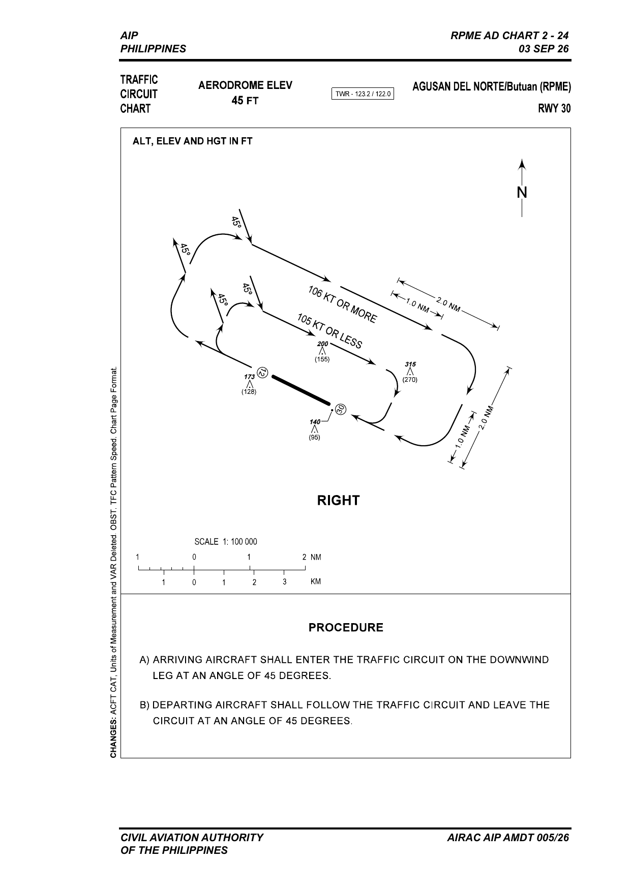
Right-hand circuit. Aircraft at 105 KT or less fly the inner circuit (1.0 NM from the runway); aircraft at 106 KT or more fly the outer circuit (2.0 NM).
Circuit entry and exit
- Arriving aircraft shall enter the traffic circuit on the downwind leg at an angle of 45 degrees.
- Departing aircraft shall follow the traffic circuit and leave the circuit at an angle of 45 degrees.
Visual Landmarks and Reporting Points
| Reporting Point | Coordinates | Distance from ARP (NM) | Relative Position | Description |
|---|---|---|---|---|
| BAYUGAN | 084252N 1254454E | 21.4 | SE | Bayugan Rotunda |
| BIT-OS | 085309N 1253228E | 5.4 | SE | National Irrigation Administration, Bit-os |
| BUENAVISTA | 085857N 1252402E | 5.0 | NW | Shoreline West of Buenavista Municipality |
| CABADBARAN | 090652N 1253129E | 10.1 | NE | Shoreline of Cabadbaran City |
| CITY HALL | 085713N 1253145E | 3.0 | E | City Hall Building, Butuan City |
| MACAPAGAL BRIDGE | 085524N 1253327E | 5.0 | SE | Longest Bridge in Mindanao crossing Agusan River |
| MAGALLANES | 090140N 1253050E | 5.0 | NW | North bank of a wide river outlet |
| MAGSAYSAY | 090049N 1251032E | 18.3 | W | Fisheries at Magsaysay Municipality |
| MAGUINDA | 084921N 1253530E | 10.3 | SE | Maguinda National High School, East of Agusan River |
| NASIPIT | 085824N 1252101E | 8.0 | W | SMCC Triangulo Campus, Nasipit |
| ODIONGAN | 085052N 1250957E | 20.0 | SW | Odiongan National High School |
| TUBAY SHORELINE | 091219N 1253315E | 16.0 | NE | Mining/Quarrying Area |
| TUNGAO | 084641N 1253411E | 12.0 | SE | Tungao Barangay Hall |