Visual Flight Rules (VFR) Within Iloilo ATZ
VFR Area Chart
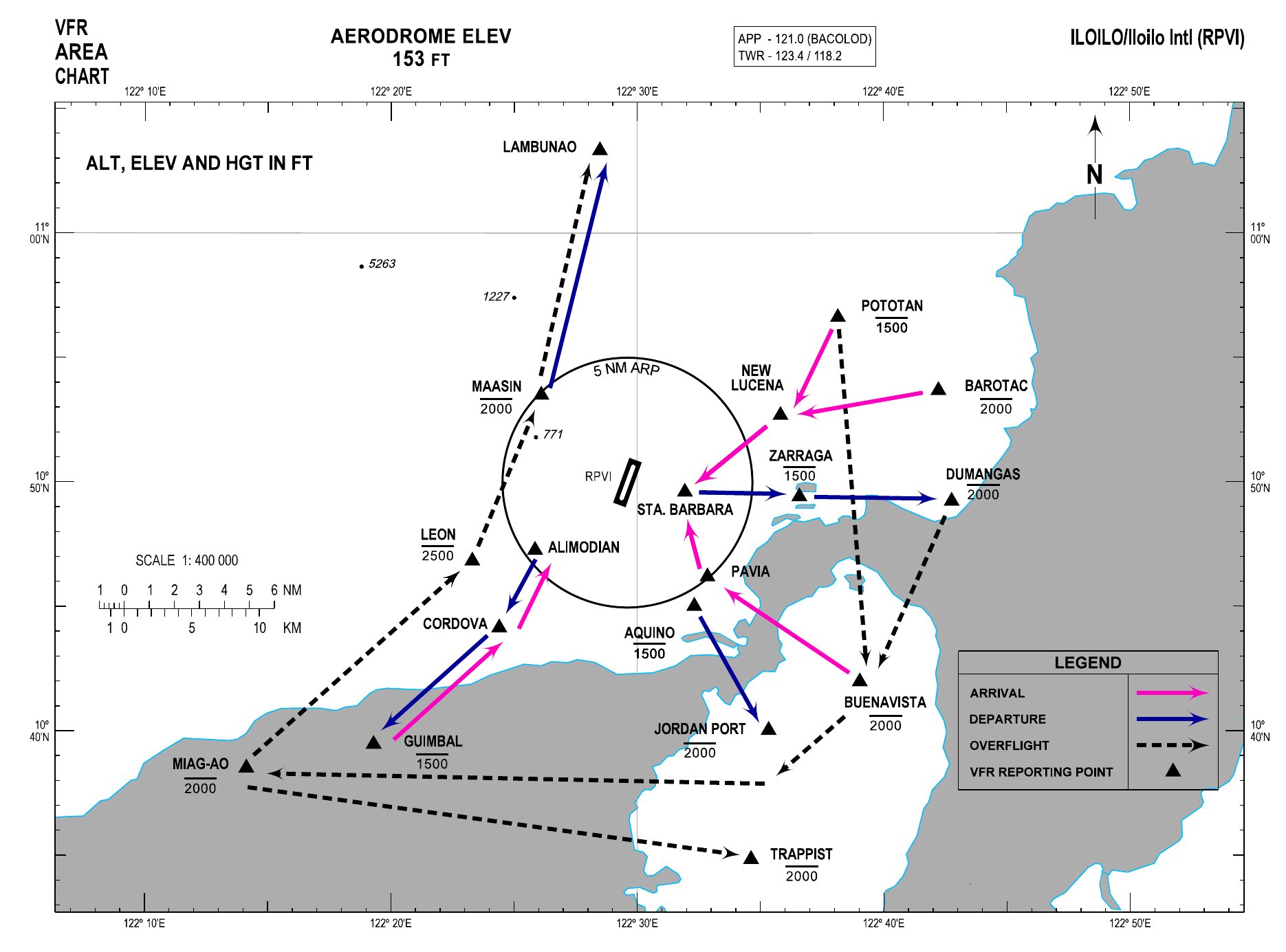
General Procedures for VFR Flights
The following air traffic procedures shall apply to all VFR flights when entering, leaving, operating, or transiting the vicinity of Iloilo ATZ.
- All departing VFR flights shall maintain a listening watch on Iloilo Tower frequency 123.4 MHZ until instructed to leave the frequency or to contact Bacolod Approach frequency on 121.0 MHZ while operating within Bacolod/Iloilo TMA.
- All arriving VFR flights shall establish contact and remain on listening watch with Bacolod Approach frequency on 121.0 MHZ upon entering Bacolod/Iloilo TMA or to establish two-way radio contact with Iloilo Tower on frequency 123.4 MHZ 10 NM inbound to the airport.
- ATC instructions and traffic information shall be acknowledged and complied with.
- When operating within Bacolod/Iloilo TMA, pilots of VFR aircraft are to conform to the following altitude restrictions unless otherwise specified in the succeeding procedures or authorized by ATC:
- from 5 NM up to 20 NM from Iloilo ARP, not higher than 2000 FT.
- All VFR traffic shall secure approval from Iloilo Tower before crossing the final approach of RWY 02/20.
- Any deviation from the procedures shall be subject to ATC approval.
VFR Departures
Northeast/East Bound: After airborne, turn right towards ZARRAGA not higher than 1500 FT. Continue towards DUMANGAS not higher than 2000 FT or proceed as instructed by ATC.
Southeast Bound: After airborne, make a right downwind departure towards AQUINO. Continue towards JORDAN PORT not higher than 2000 FT or proceed as instructed by ATC.
Southwest Bound: After airborne, make a left downwind departure towards ALIMODIAN. Continue towards CORDOVA, then towards GUIMBAL not higher than 1500 FT or proceed as instructed by ATC.
North Bound: After airborne, turn left towards MAASIN not higher than 2000 FT. Continue towards LAMBUNAO or proceed as instructed by ATC.
Northeast/East Bound: After airborne, make a left downwind departure towards ZARRAGA not higher than 1500 FT. Continue towards DUMANGAS not higher than 2000 FT or proceed as instructed by ATC.
Southeast Bound: After airborne, turn left towards AQUINO then towards JORDAN PORT not higher than 2000 FT or proceed as instructed by ATC.
Southwest Bound: After airborne, turn right towards ALIMODIAN. Continue towards CORDOVA, then towards GUIMBAL not higher than 1500 FT or proceed as instructed by ATC.
North Bound: After airborne, make a right downwind departure towards MAASIN not higher than 2000 FT. Continue towards LAMBUNAO or proceed as instructed by ATC.
VFR Arrivals
From the Northeast/East: Report approaching POTOTAN not higher than 1500 FT or BAROTAC not higher than 2000 FT. Fly towards NEW LUCENA. Continue towards STA. BARBARA and request clearance to cross overhead, North side of the ATC Control Tower to join downwind RWY 02 or proceed as instructed by ATC.
From the Southeast: Report approaching BUENAVISTA not higher than 2000 FT. Continue towards PAVIA then towards STA. BARBARA and request clearance to cross overhead, North side of the ATC Control Tower to join downwind RWY 02 or proceed as instructed by ATC.
From the Southwest: Report approaching GUIMBAL not higher than 1500 FT. Fly towards CORDOVA, then towards ALIMODIAN. Request clearance to join base or final RWY 02 or proceed as instructed by ATC.
From the Northeast/East: Report approaching POTOTAN not higher than 1500 FT or BAROTAC not higher than 2000 FT. Fly towards NEW LUCENA. Request clearance to join base or final RWY 20 or proceed as instructed by ATC.
From the Southeast: Report approaching BUENAVISTA not higher than 2000 FT. Fly towards PAVIA. Request clearance to join downwind RWY 20 or proceed as instructed by ATC.
From the Southwest: Report approaching GUIMBAL not higher than 1500 FT. Fly towards CORDOVA, then towards ALIMODIAN. Continue towards West of the airport and request clearance to cross overhead, South side of the ATC Control Tower, to join downwind RWY 20 or proceed as instructed by ATC.
VFR Procedures for Overflights
From the Northeast/East to the South: Report approaching POTOTAN not higher than 1500 FT or DUMANGAS not higher than 2000 FT. Continue towards BUENAVISTA or proceed as instructed by ATC. Report leaving Iloilo Tower frequency.
From the Northeast/East to the Southwest: Report approaching POTOTAN not higher than 1500 FT or DUMANGAS not higher than 2000 FT. Continue towards BUENAVISTA. Fly towards South of JORDAN PORT. Request clearance to cross final approach RWY 02 towards MIAG-AO not higher than 2000 FT or proceed as instructed by ATC. Report leaving Iloilo Tower frequency.
From the Southeast to the Southwest: Report approaching South of JORDAN PORT not higher than 2000 FT. Request clearance to cross final approach RWY 02 towards MIAG-AO or proceed as instructed by ATC. Report leaving Iloilo Tower frequency.
From the Southwest to the Southeast: Report approaching South of MIAG-AO not higher than 2000 FT. Request clearance to cross final approach RWY 02 towards TRAPPIST or proceed as instructed by ATC. Report leaving Iloilo Tower frequency.
From the Southwest to the North: Report approaching MIAG-AO not higher than 2000 FT. Fly towards LEON not higher than 2500 FT. Continue towards LAMBUNAO via MAASIN not higher than 2000 FT or proceed as instructed by ATC. Report leaving Iloilo Tower frequency.
Helicopter Operations
- VFR helicopter flights shall be treated as fixed wing aircraft and will follow the same established VFR routes and procedures for Iloilo International Airport.
- Except when clearance is obtained from Iloilo Tower, VFR helicopter flights shall not take-off/lift-off or land at Iloilo International Airport or enter its ATZ when the:
- ceiling is less than 150 M (500 FT); and
- ground visibility is less than 1.5 KM (1 mile).
- Helicopters operating VFR may be allowed outside controlled airspace with flight visibility below 1.5 KM (1 mile) provided that:
- the helicopter is clear of clouds and ground or water is in sight at all times; and
- the helicopter shall be maneuvered at a speed that will give adequate opportunity to observe other traffic or any obstruction to avoid collision.
Visual Landmarks and Reporting Points
| Reporting Point | Coordinates | Distance from ARP (NM) | Relative Position | Description |
|---|---|---|---|---|
| ALIMODIAN | 104716N 1222551E | 4.6 | SW | Alimodian-Leon Junction Road |
| AQUINO | 104501N 1223219E | 5.6 | SE | C-1 and Old Iloilo-Capiz Road Intersection |
| BAROTAC | 105341N 1224214E | 13.0 | NE | Barotac Nuevo Plaza Field |
| BUENAVISTA | 104159N 1223902E | 12.2 | SE | Guimaras State University Oval Field |
| CORDOVA | 104409N 1222424E | 7.7 | SW | House in the Middle of Ricefield |
| DUMANGAS | 104914N 1224246E | 13.0 | E | San Agustine Parish Church, Dumangas |
| GUIMBAL | 103928N 1221918E | 14.6 | SW | Guimbal Port |
| JORDAN PORT | 104002N 1223520E | 11.4 | SE | Jordan Jetty Port |
| LAMBUNAO | 110319N 1222829E | 13.3 | NW | Lambunao Public Plaza |
| LEON | 104650N 1222318E | 7.0 | SW | Leon Town Plaza |
| MAASIN | 105330N 1222606E | 4.9 | NW | Maasin Public Market |
| MIAG-AO | 103831N 1221408E | 19.0 | SW | Miag-ao Santo Tomas Church |
| NEW LUCENA | 105241N 1223549E | 6.7 | NE | New Lucena Circular Sports Building |
| PAVIA | 104612N 1223251E | 5.0 | SE | Anilao Bridge, at Diverging Flood Canal |
| POTOTAN | 105637N 1223809E | 10.7 | NE | Pototan Coliseum |
| STA. BARBARA | 104936N 1223156E | 2.3 | E | Sta. Barbara Plaza and Football Field |
| TRAPPIST | 103451N 1223437E | 15.9 | SE | Trappist Monastery |
| ZARRAGA | 104925N 1223635E | 6.9 | E | Zarraga Catholic Church |